

"Everyone talks about the weather,
but nobody does anything about it."

Points to Ponder: Calculate the altitude of aircraft using a digital camera.
October 2004: With the whole sky above the Holmestead filled with these aircraft and their noxious work we asked once more how high are they actually flying.
We may have a method to answer that question - if you have a good digital camera.
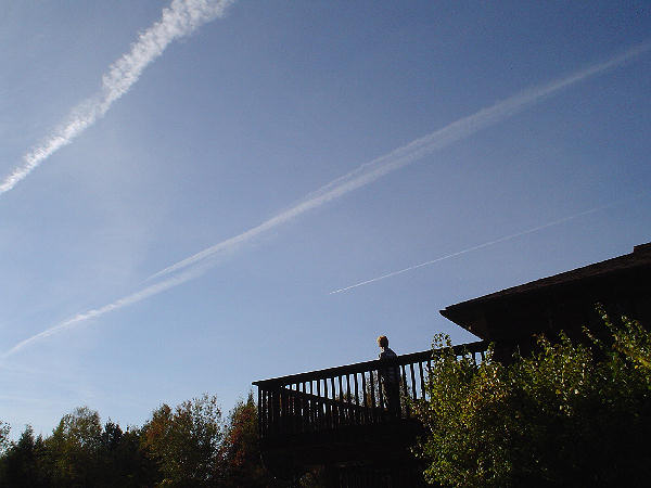
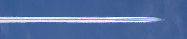
The above photograph was taken on 19 October 2004 at 1.23 PM approximately 15 km NE of Bancroft, Ontario, in Herschel Township.
The aircraft was seen spraying a heavy plume horizon to horizon and heading in an easterly direction. The weather in most of central Ontario that day was clear and bright and, although there had been frost overnight, by noon the day was above average in temperature for the time of year. Note that the cloud cover seen in this image is at a higher altitude than the aircraft. The digital camera used had a 190mm equivalent focal length lens and a whole series of such photographs were taken - all around the same time.
 Update May 2010: The above was the basic description online since 2004 - but for the last year or so I have been mulling over this: I now have the official weather records from that date and time - so at 13:00 hours, the approximate time of the photograph in question, this is the weather information from Environment Canada National Climate Data and Information Archive: Bancroft data: Temp: 6.9°C - Dew Point Temp: 0.0°C - Relative Humidity: 61% plus the elevation of the reporting station - that being the local airport - is 330.70 metres. Update May 2010: The above was the basic description online since 2004 - but for the last year or so I have been mulling over this: I now have the official weather records from that date and time - so at 13:00 hours, the approximate time of the photograph in question, this is the weather information from Environment Canada National Climate Data and Information Archive: Bancroft data: Temp: 6.9°C - Dew Point Temp: 0.0°C - Relative Humidity: 61% plus the elevation of the reporting station - that being the local airport - is 330.70 metres.
So, using one of several online calculators that are typically used for establishing Visual Flight Rules for light aircraft, and using such a calculator the cloud base in the general lcation at the time of the photograph is shown to be at approximately 4,000 feet.
This is the calculator used - along with the background reasoning: Cumulus Cloud Base Calculator
Perhaps I am overlooking something but if you follow through with the arguments offered in the rest of this page you will see that the clouds seen in the image that is used here are suggested as being lower in altitude by the Cloud Base Calculator than the following calculations of the altitude of the aircraft itself.
I have been in touch with several individuals, including military, on this apparent anomaly but no satisfactory answer has been forthcoming. Perhaps the camera was at a somewhat different elevation - but although the area is hilly it is not mountainous so that possibility might account for a thousand feet or so.
So to continue:
The photographer also commented upon how quiet the aircraft were. Another aircraft photographed at this time was the less common three engine variety that has not been positively identified but is perhaps the KC-10.
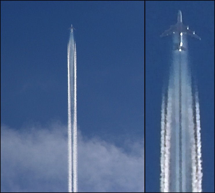
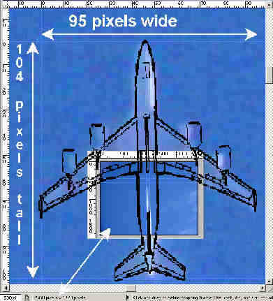
From this series of photographs one was selected and a pixel scale added. If you are not familiar with the term pixel it means pix plus element or in other words the basic unit of digital or video images.
Today we would have more precise detail due to the increase in megapixel specifications of the latest digital cameras but in 2004 this is what we had available (2560 x 1920 pixels) so here this rather fuzzy aircraft image, showing some reddish or off-color pixel artifacts all over the aircraft plus the sky due to the extreme blowup, is checked against a standard KC-135R outline and it is a match:
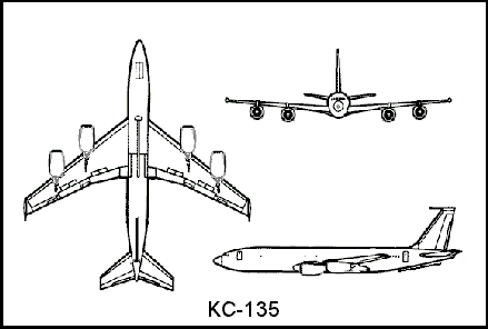
Before continuing it might be noted that the above identification is as certain as it is because although Boeing based the KC-135 upon the same design as the 707 family of early jetliners that first flew some fifty years ago, today there are no airlines using the 707 in passenger service - certainly not in North America. Therefore it is highly unlikely that this particular aircraft could be of civilian or commercial origin. It is reported that there are a few of the later series of 707 aircraft still in service with pure cargo airlines but with noise reduction restrictions in place at all major airports their use is extremely limited - perhaps only to use within third world countries.
For further related information visit the Boeing web site: KC-135 and 707
The aircraft specifications are readily available online and the wingspan is 130ft 10in - so let us say 131 feet for these purposes.
The width of the image in pixels and the aircraft wingspan in pixels can be used to provide a ratio. This ratio, when multiplied by the actual aircraft wingspan in feet or meters, will provide an estimation of the real-world field-of-view of the photograph.
Did you get that?
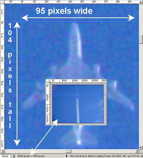
From the camera specification - or more than likely, the actual image pixel size as seen with the graphic software that you are using - we know that the camera has 2560 pixels horizontally - so (in this case) divide that by 95 (the pixel wingspan) and we come up with 26.947
Here you may not be using a pixel scale as seen above but simply crop closely and that image will display your aircraft pixel count.
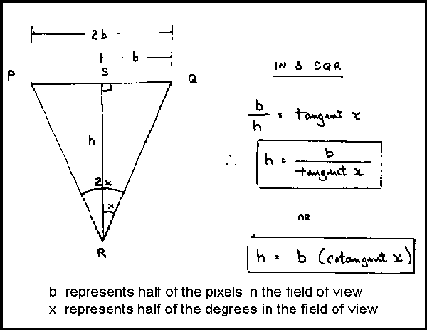
Multiply the actual wingspan of 131 ft by 26.947 and that is the Horizontal Field Of View (HFOV) in feet of this camera (with these lens settings and at the altitude of the aircraft). The figure is 3,530 feet HFOV.
Again, from the camera specifications, we know the horizontal angle of view at the particular settings used - it is 10.26 degrees. Therefore, in the diagram below and in this particular example: 2b=3530 and 2x=10.26
Fortunately now we don't have to go through that mathematical exercise - see below!
ALTITUDE CALCULATOR
The calculator below gives the actual altitude of the above observations - it is 19,660 ft - which seems like a logical value as it is the 20,000 ft height that is often reported or guessed in these discussions. Just click on the |Calculate| button to see this result displayed!
Please note that the form you see below initially displays the actual figures from this current example so just click on calculate! Then, if you wish, edit the values and enter your own Camera and Aircraft figures if you have taken such photographs and your answer will be automatically generated for you. You must have javascript enabled on your browser.
The calculation below calls for the angle of view in degrees of the lens of the camera. If these values are not directly listed in the camera instruction manual this supplementary Angle of View Calculator is available.
|
Of course, we must allow for some margin for error in this final figure as the original pixel count from the greatly enlarged images might be slightly inaccurate.
The figures here are in feet as that seems to be traditional for North American aviation but our friends in Europe may be thinking in terms of meters. All they would have to do is enter their values in metric and the final result would be in meters. For example, the wingspan of 131 feet equals 39.93 meters and the final result of 19,660 feet equals 5,992.37 meters.
It has been stated many times before - this modest altitude of some 20,000 feet on a relatively warm day is not cold enough to create traditional engine exhaust moisture condensation trails. Commercial jetliners fly much higher than 20,000 feet on long inter or trans continental flights.
|
Points to Ponder: Calculate the airspeed of aircraft using a digital camera.
After some further head scratching I offer this approach to estimating the airspeed of aerial craft based again upon the use of a good quality digital camera. It is easier to execute than to explain!
The principle used is as above and that is that if the altitude of the craft can be measured, or perhaps estimated given a certain amount of experience, then the "size" of that piece of sky is known. This is established based upon the field of view of the particular digital camera.
It then follows that if the passage of the craft through that particular airspace can be timed then the airspeed can be closely estimated.
Although we do know from published sources that the cruising speed of traditional aircraft such as the KC-135R studied above is perhaps of the order of 500-600 mph there have been a number of reports of aerial craft actively spraying but flying at speeds that appear to approach or exceed the speed of sound. It would be interesting to observe and make an estimate of the speed of one of those as these cannot be standard aerial tankers!
This is the step by step outline of the method - it will of course, require a clear line of sight and a reasonably clear sky:
When you see an aircraft approaching that appears as if it might pass somewhere overhead place your digital camera on a firm surface (of course, a tripod would be ideal if you had time or were prepared) pointing upwards. The lens should be set for the widest angle possible because (unlike the altitude calculation above) you do not require close up details but a wide field of view. Start shooting photographs every few seconds but do not displace the camera between each shot. When the aircraft has passed out of the frame, as you might expect it would, check you shots.
What you are looking for is a pair of images that show the aircraft close to each opposite edge of the frame - or in other words - as far apart as possible in the two images.
If you are satisfied retire to your computer and then carry out the next steps.
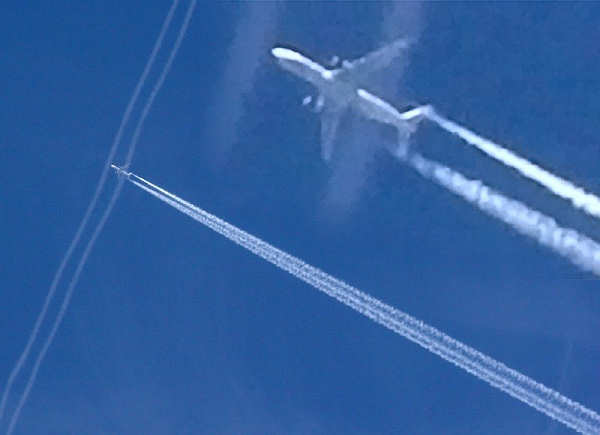
Here are samples of two such images which for clarity have been simulated:
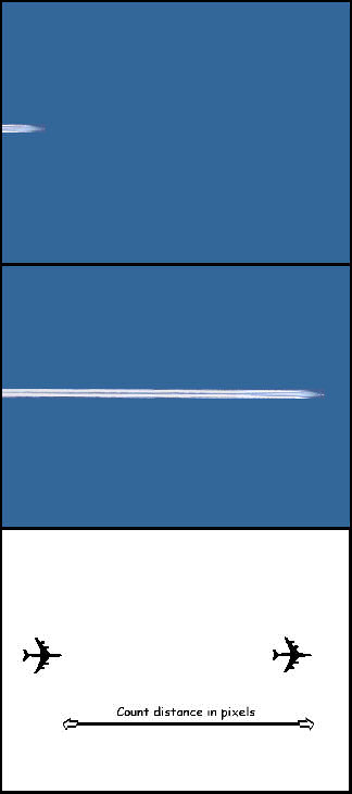
The lowest section of the graphic above is intended to convey the principle of making a "count" of the pixels between the two positions of the aircraft. Of course, this is done directly by your graphics software where the values are read from the original image files displayed on your monitor screen and all that is required is to rest the mouse on the appropriate point of the images.
The pixel value of the first position of the aircraft is noted and then the second and the difference between these two values is the "distance" in pixels traveled by the craft.
At this point also make a note of the total width of your image in pixels as this is required for the calculation to follow.
Yes, but what about the time the aircraft took to move that distance?
That is already on hand as any adequate digital camera will automatically record the time down to the second that the photograph was taken. Your digital camera is a "stopwatch"!
This is contained in the EXIF data. Your graphics software should have an Image Information button. (For graphics software see below) Click on that and there you will see EXIF - open that and there - along with a great deal of other information about your photograph - will be the exact time that the photographs were taken.
This information may only be available only in the original image and may very well be lost if the image is resized or for example, saved in another format.
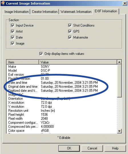
The above is a sample of typical EXIF Information as displayed in a graphics software application - yours may differ in some way.
If you note the time that each of your selected photographs was taken then the difference between the two times is the elapsed time.
If the Angle of View in degrees of your camera is not recorded in the EXIF data then first make use of this "35mm equivalent focal length" calculator. In the digital camera specifications handbook there may be an expression such as: "35 mm camera conversion or equivalent". That figure will be the focal length of the camera lens as equivalent to a regular 35 mm film camera. It may be something like 33, 39 or 41 mm etc.
You will probably only require the resulting Horizontal Field of View but other figures are available.
Please note that the calculator form you see below initially displays hypothetical values for this demonstration. So for any actual measurement you wish to make edit the values and enter your own figures before Calculating.
Enter this Angle of View or Field of View value in degrees in the appropriate panel of the main "Velocity Calculator" below.
Then enter the other values you have recorded - click the |Calculate| button to see displayed the estimate of actual airspeed in various forms.
Please note that the calculator form you see below initially displays hypothetical values for this demonstration. So for any actual measurement you wish to make edit the values and enter your own figures before Calculating.
|
I hope all of my explanations are understood and you are able to obtain some worthwhile results. If so, please consider telling me about what you have found. The e-mail link is below.
|
Graphics and photographic software
If you do not have any high end graphics software such as Paint Shop Pro or Photo Shop on your computer then consider the excellent freeware from:
Irfanview
It is for Windows 9x, ME, NT, 2000, XP, 2003, 2008, Vista, Windows 7.
Add some free plugins while you are there!
|
Holmestead.ca wishes to acknowledge the valuable contribution of the local "Skywatcher" who provided the excellent aircraft photographs, the digital camera specifications and the scaled versions of the images with pixel rulers that made this page possible. This expert photographer has wished to remain anonymous and now - may he Rest In Peace.
Also, I would like to thank my good friend Prof. Jim for his diagram and helping me brush up on my trigonometry - it has been a long time!
Many thanks.
|
You are invited to contact us at the "Holmestead".
|